Configuration of OGC API - Features module
The service operates as an additional protocol for sharing vector data alongside Web Feature Service.
Service configuration
The service is configured using the Vector Services page:
-
Shared Service metadata to define title, abstract, and keywords.
Note
The service title is shared with WFS, so when upgrading from GeoServer 2.28 configuration it will read
GeoServer Web Feature Serviceuntil you change it. -
Configuration shared by Web Feature Service (WFS) for output formats.
-
Contact information defined in Contact Information.
-
Extra links can be added on a per-service or per-collection basis as indicated in OGC API Service Configuration.
Feature Service Conformances
The OGC API Feature Service is modular, with supported functionality listed in a conformance document.
Use the provided Conformance tables to manage each group of standards:
-
OGC API Feature conformances.
Disabling a class removes it from the
conformancedocument. What else changes depends on the kind of class: some manage the contents of the API document, while others add resources or request parameters to the service.Standard:
-
crsByReference: when disabled, thefilter-crsparameter is removed from the API document, and acrsparameter is ignored, returning features inEPSG:4326. -
gml321: when disabled, GML 3.2.1 output is no longer advertised in the API document. -
queryables: when disabled, the queryables resource is removed from the API document. -
featuresFilterandfilter: require a filter language, see below.
Draft standard, disabled by default:
-
ids,sortByandpropertySelection: when enabled, theids,sortby,propertiesandexclude-propertiesparameters are added to the API document and used when handling a request. When disabled, they are not included in the API document, and are ignored if used. -
search: when enabled, the/searchresource is listed in the API document. When disabled, it is not listed and answers with a404status.
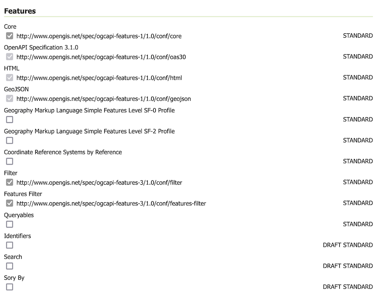
Feature Service Configuration -
-
CQL2 Filter conformances.
Both the Text and JSON formats for CQL2 are available and may be enabled or disabled.
The CQL2 capabilities implemented by GeoServer (basic, advanced comparison, arithmetic, property-property, and spatial operators) are built-in, and included in the
conformancedocument when CQL2 Text or CQL2 JSON is enabled.CQL2 Functions provides the
/functionsresource, listing the functions available for use in a filter.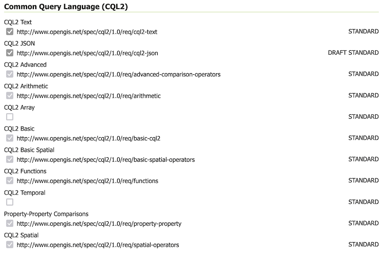
CQL2 Filter configuration -
Control of ECQL Filter conformances

ECQL Filter configuration -
The enabled filter languages are listed in the
filter-langparameter of the API document, and the first one is its default. A request using any other language gets a400status.With every language disabled the filter parameters are not available at all: the filter conformance classes are no longer included in the
conformancedocument, the parameters are removed from the API document, and afiltersent anyway is ignored.In the tables this shows as Filter and Features Filter in light gray when every filter language is disabled. Features Filter also needs Filter.

Filter and Features Filter require a filter language to be enabled
For more information see Status and Conformance table.