OGC API - Maps
A OGC API - Maps implementation aligned to version 1.0.0, delivering:
- Collection listing, and styles per collection
- Map of a collection, in the default style or in any style associated to it
- Map of the whole dataset, drawing several collections in one image, chosen and ordered with the
collectionsparameter - API definition (OpenAPI 3), filtered to the conformance classes enabled on the server
- Optional map parameters, listed under Requesting a map
- Attribute filtering of the rendered features, with the queryable attributes of each collection
- Three GeoServer extensions outside the standard: feature info on a map, legends, and the binding of the filter parameters to the map resources
Missing functionality at the time of writing:
- Maps specific metadata (e.g., scale ranges)
- A style applied to a dataset map: each collection is drawn in its own default style (not part of the standard)
- Map tilesets (delivered by the separate OGC API - Tiles module)
OGC API - Maps Implementation status
| OGC API - Maps | Version | Implementation status |
|---|---|---|
| Part 1: Core | 1.0.0 | Implemented for collection maps and dataset maps, with the optional classes listed above. |
Installing the GeoServer OGC API - Maps module
-
Login, and navigate to About & Status > About GeoServer and check Build Information to determine the exact version of GeoServer you are running.
-
Visit the website download page, change the Development tab, and locate the nightly release that corresponds to the GeoServer you are running.
Follow the Community Modules link and download
ogcapi-mapszip archive.- 3.1.0-SNAPSHOT example: ogcapi-maps
The website lists active nightly builds to provide feedback to developers, you may also browse for earlier branches.
Warning
Verify that the version number in the filename corresponds to the version of GeoServer you are running (for example geoserver-3.1.0-SNAPSHOT-ogcapi-maps-plugin.zip).
-
Extract the contents of the archive into the
WEB-INF/libdirectory in GeoServer. -
Restart GeoServer.
On restart the services are listed at http://localhost:8080/geoserver
The Maps landing page is at http://localhost:8080/geoserver/ogc/maps/v1, linking to the API definition, the collections, the dataset map and the conformance classes.
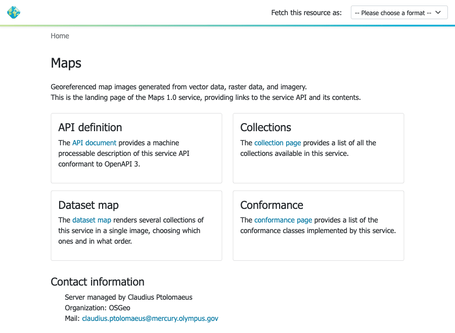
OGC API - Maps landing page
Configuration of OGC API - Maps module
The module shares the same mapping engine as WMS, follows the same configuration and exposes the same layers. As a significant difference, Maps does not have a concept of layer tree, so only individual layers and groups can be exposed.
Turning optional functionality off
As with other OGC APIs, Maps exposes conformance classes, which can be managed individually from the Services > Mapping settings page in the admin UI, on the Maps tab.
A table lists each optional class with an Enabled checkbox, plus the Collections in a dataset map field described in Requesting a map of several collections.
Use the provided Conformance tables to manage each group of standards:
-
OGC API Maps conformances
Disabling a class removes it from the
conformancedocument. What else changes depends on the kind of class: some manage the contents of the API document, while others add resources or request parameters to the service.Standard:
-
A parameter class (
spatialSubsetting,generalSubsetting,scaling,displayResolution,datetime,crs,background,orientation): when disabled, the parameter is ignored, following the OGC API convention of ignoring unsupported query parameters, and the map is returned as if it had not been provided. WithgeneralSubsettingdisabled, the elevation and custom-dimension axes of asubsetare dropped rather than rejected. -
An output format class (
tiff,svg): when disabled, the format is no longer offered, so a request for it fails HTTP content negotiation with a406status. -
datasetMap: when disabled, the/mapresource and its feature info go away, and the landing page stops linking them and stops publishing anextent. Collection maps are not affected. -
collectionsSelection: when disabled, thecollectionsparameter is ignored, so the dataset map always draws the default contents, and the preview offers no palette. The class needsdatasetMapto mean anything, so disabling that disables both.
Community standard:
-
featureInfo: when disabled, the feature info resource answers with a404status. -
legend: when disabled, the legend resource answers with a404status, and the styles document offers no legend formats. -
mapFilter: see the filter classes below.
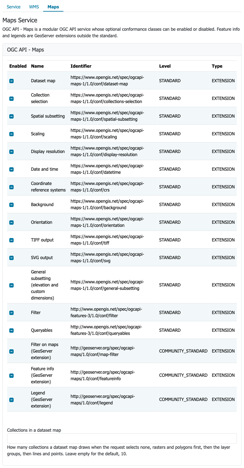
Maps conformance classes -
-
CQL2 Filter conformances.
Both the Text and JSON formats for CQL2 are available and may be enabled or disabled.
The CQL2 capabilities implemented by GeoServer (basic, advanced comparison, arithmetic, property-property, and spatial operators) are built-in, and included in the
conformancedocument when CQL2 Text or CQL2 JSON is enabled.CQL2 Functions is not listed, as Maps does not provide a
/functionsresource.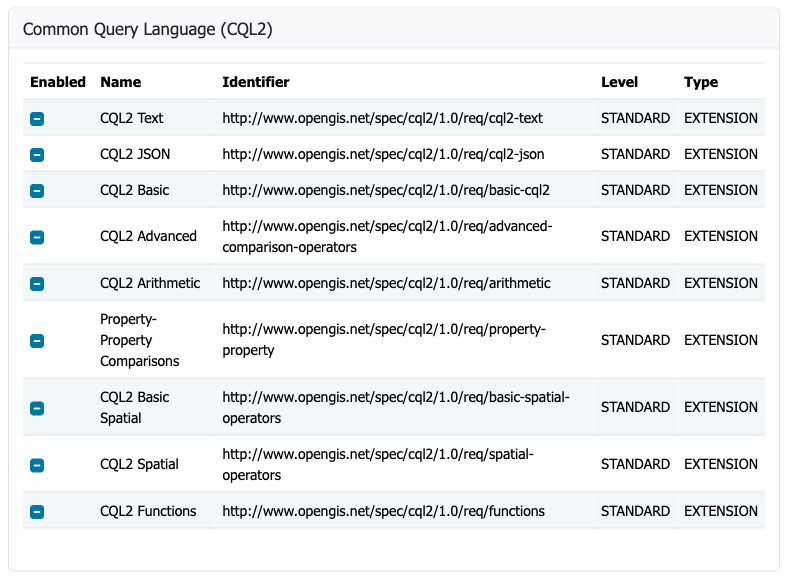
CQL2 filter configuration -
Control of ECQL Filter conformances
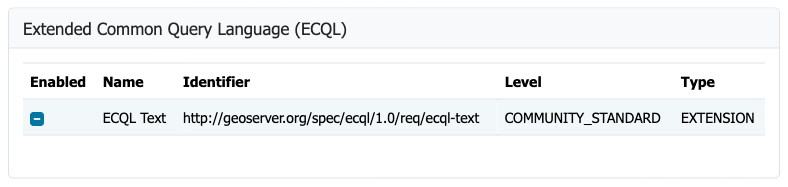
ECQL filter configuration -
The filter classes (
filter,mapFilter, the language ones) andqueryables: filtering needsfilter,mapFilterand at least one language, so turning off any of them ignores thefilterparameter and takes the queryables away with it. See Filtering a map.In the figure below Filter on maps is disabled, so Filter and Queryables are shown in light gray even though both are left to their default, which is enabled.
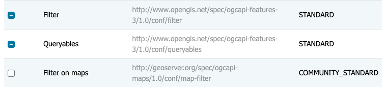
Filter and Queryables require Filter on maps
Requesting a map
A map of a collection is retrieved from /ogc/maps/v1/collections/{collectionId}/map, or from
.../styles/{styleId}/map to pick a style other than the default one. The output format is chosen with the f
parameter, PNG and JPEG are always available, TIFF and SVG can be turned off via conformance classes,
in general, other output formats can be removed in the mapping configuration panel as well.
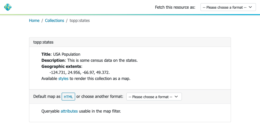
Collection page
The format can also be negotiated with the Accept header, in place of f. A client that lists PNG and JPEG
with the same quality, and nothing it prefers more, lets the server choose: a map with transparency comes back
as PNG, an opaque one as JPEG, which compresses it better. Give one of the two a higher quality, for example
Accept: image/png, image/jpeg;q=0.5, to make the choice explicit.
The area, size and appearance of the map are controlled by the parameters of the optional conformance classes:
bboxandbbox-crs,subsetandsubset-crs, orcenterandcenter-crs, to pick the area. Acenterrequest also needswidth,heightandscale-denominator, since a point alone does not define an extent.subsetcan be also used to select along dimensions beyond space and time, when general subsetting is enabled: the elevation and any custom dimension declared on the layer, for examplesubset=elevation(500)orsubset=<dimension>(<value>), withlow:highfor a range. The dimensions available on a collection, and their ranges, are listed in the collection description underextent. An axis that is not a dimension of the collection is rejected with a400status.widthandheight, orscale-denominator, to size the image. If you leave out the width or the height, GeoServer computes it, see Map size and shape below.mm-per-pixel, the size of a pixel on the display, 0.28 mm when not given.datetime, to select a time in a layer with a time dimension.crs, the CRS of the delivered map. Both the extendedhttp://www.opengis.net/def/crs/EPSG/0/4326form and the SafeCURIE[EPSG:4326]form are accepted; these forms follow the axis order declared by the CRS authority, while a plainEPSG:4326is always longitude/latitude. The same holds forbbox-crs,subset-crsandcenter-crs.bgcolor,transparent,void-colorandvoid-transparent, for the map background.-
orientation, to rotate the map, in degrees. -
filter,filter-langandfilter-crs, to render only the features matching a filter. See Filtering a map below.
Every response carries the delivered area back in the Content-Crs, Content-Bbox, Content-Orientation and
Content-Datetime headers. Content-Bbox follows the axis order of the CRS authority, so for EPSG:4326 it reads
latitude,longitude, and it always reports the area before any rotation. Content-Crs holds the CRS URI between
angle brackets, for example <http://www.opengis.net/def/crs/EPSG/0/4326>, and is omitted when the CRS has no
authority code, for example when using an AUTO code. Content-Orientation is the rotation applied, zero for a map with the default orientation.
The CRSs a map can be delivered in are advertised as CRS URIs by the collection description, in its crs
property, and by the /collections document, which lists them once at its root so that each collection can
point at that single list with #/crs. The list is the Services > Mapping SRS list when one is configured,
otherwise it's all the known codes. A collection whose storage CRS is
not CRS84 also reports it as storageCrs, adding it to the crs list, and repeats its extent in that CRS under
extent.spatial.storageCrsBbox. That is the CRS a map is delivered in when the request does not ask for another
one, so no reprojection takes place.
These two resources are GeoServer extensions as well, not part of the standard:
.../map/info, the feature information at a pixel, selected with theiandjparameters.limitsets the maximum number of features returned, one by default, counted across all the layers of the collection: a layer group needs a higher limit to report something from more than one of its layers. The pixel is read from the same map themapresource returns, so all the map parameters above apply here too, and the reported features are the ones the map shows.orientationis the exception, it is currently ignored: the pixel is always read from the map as it would be drawn without rotation, so on a rotated map use themapresource to see the rotation and this one to query it. When nobbox-crsis given,crsapplies to thebboxas well. Unless otherwise specified, the parameters supported by a WMS GetFeatureInfo are also available in the.../map/inforesource..../legendand.../styles/{styleId}/legend, the legend of a style, with the samewidth,height,scale,rule,lang,transparent,bgcolorandlegend-optionsparameters as the WMSGetLegendGraphicrequest.
Maps is subject to the same service limits as WMS: memory, rendering time, maximum dimensions, and so on.
Map size and shape
When the request gives no width or no height, the standard requires the missing one to be computed from the size of
the area on the ground, and not from the span of its coordinates. See parts H of the
width and
height requirements, and the
scale and aspect ratio considerations that describe
the computation. The two measures differ: one degree of longitude is about 111 km at the equator and about 56 km at 60
degrees of latitude, while one degree of latitude is about 111 km everywhere. Projected CRSs have the same problem in
their own units, a Web Mercator "metre" is a real metre at the equator only.
The results might be surprising for those with a WMS background:
- A geographic map away from the equator comes out taller than its bounding box suggests. A box of 10 by 10 degrees at 60 degrees of latitude covers about 558 km east to west and about 1114 km north to south, so the image is about twice as tall as it is wide. The square image a WMS returns for the same box is the stretched one, when ground distances are considered.
- GeoServer measures at the centre of the map, one of the ways the standard allows. A large map is correct in the middle, and progressively wrong towards its edges. No single image size can be correct everywhere, and the standard warns that two servers may answer the same request with slightly different sizes.
- GeoServer still computes the scale of a style from the coordinates, the WMS way. On a large map, or far from the
equator, the style is drawn with the rules of a somewhat different scale than the
scale-denominatorasked for.
Send bbox, width and height together, as in a WMS request, to keep full control: GeoServer then computes nothing.
Requesting a map of several collections
A map of the whole service is retrieved from /ogc/maps/v1/map, linked from the landing page. It takes the same
parameters as a collection map, plus collections, a comma separated list choosing what to draw:
The collections are drawn in painter's order, the first one at the bottom and the last one on top. Each entry is either a collection identifier or the full URL of its collection resource. A layer group counts as a single collection, and keeps its own internal layer order and per-layer styles. Every collection is drawn in its own default style: OGC API - Maps 1.0.0 has no way to pick a style per collection.
Without collections the map draws the contents of the service it was addressed to: the layer or layer group of
a virtual service, or a selection of the collections of the
workspace, or of the whole catalog at the root. Drawing a whole catalog would be both slow and the map likely unreadable, so the
map holds at most the number of collections set in Services > Mapping on the Maps tab (10 by default). The collections are picked
in two steps: first the layer groups, being curated, then the layers by name until the limit is reached, leaving out any
layer already drawn as a member of one of those groups. The selection is then stacked bottom to top as rasters,
polygon layers, layer groups, lines and points, so that the least covering layers stay on top. Ask for the
collections you want in collections to get anything else: that list is never cut.
Maps leaves out the same layers the WMS capabilities document does: disabled layers, layers not advertised, vector
layers without a geometry, and layer groups nested in another group. A group in CONTAINER mode cannot be drawn on
its own, as in WMS, so its members are collections instead. A layer drawn as part of a group is not drawn a second
time on its own, whatever the mode of the group; ask for it in collections to have it drawn separately.
Naming a collection that does not exist, or one that cannot be drawn, fails with a 400 status.
The landing page describes what the dataset map covers, in an extent property built like the one of a
collection, and the CRSs it can be delivered in, in a crs property. The extent covers the default contents,
in CRS84, and reports no temporal range: working one out would mean reading the time domain of every collection.
The dimension parameters apply as they do in WMS: one datetime or subset value drives every collection having
that dimension, and the collections that do not have it are drawn whole. A request fails only when none of the
collections has the dimension asked for. A filter is applied to every collection drawn, so it is only useful on
collections sharing the attributes it names.
The HTML view of the dataset map is an interactive preview with a collection palette: pick the collections to
draw from the list of candidates, and move them up and down to change the drawing order. .../map/info, the
GeoServer feature info extension, works on the dataset map too, reporting across the collections drawn.
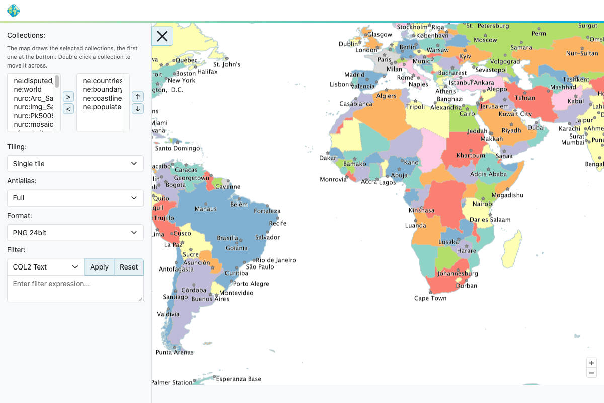
Dataset map preview with the collection palette
Filtering a map
Filtering is not part of OGC API - Maps 1.0.0. GeoServer applies the filter parameters of OGC API - Features - Part 3: Filtering to the map resources, so only the features matching the filter are rendered. Binding those parameters to the map resources is itself a GeoServer extension, declared as a separate conformance class. The request parameters are:
filter, the filter expression.filter-lang, its language:cql2-text(the default),cql2-json, orecql-text, the GeoServer own Extended CQL. XML filters and feature identifiers are not supported, though they might be added in the future. Only the languages enabled in the service configuration are accepted, the API document lists them in thefilter-langparameter, and any other value gives a400status.filter-crs, the CRS of the geometry literals used in spatial predicates. Defaults to CRS84.
For example, to render only the roads whose type is a motorway:
The filter is combined with bbox, datetime and subset by AND, so a feature is drawn only when it satisfies
all of them. The same parameters work on the .../map/info resource, so the feature info reports only the
features that the map shows. An invalid expression, an unknown language, or an unknown CRS is answered with a
400 status.
The attributes that can be used in a filter, with their types, are listed by the queryables resource:
It answers a JSON Schema document (application/schema+json), also available as HTML, and is linked from the
collection description. A vector layer lists the attributes of its features. A raster layer lists them only when
it is structured, an image mosaic for example: the filter then selects which files to mosaic, using the attributes
of the index, such as the file location, the time of ingestion or the elevation. Other raster layers, and layer
groups, answer with a 404 status, a layer group because each of its members has its own set of attributes.
A filter naming an attribute that none of the collections drawn lists as a queryable is answered with a 400
status, rather than being quietly dropped, so a typo in an attribute name shows up right away. On a map of
several collections, or on a layer group, the attribute only has to be a queryable of one of them, since the
collections can have different schemas, and it is applied to every one of them.
The map preview allows to pick a filter and a filter language in its tool box.
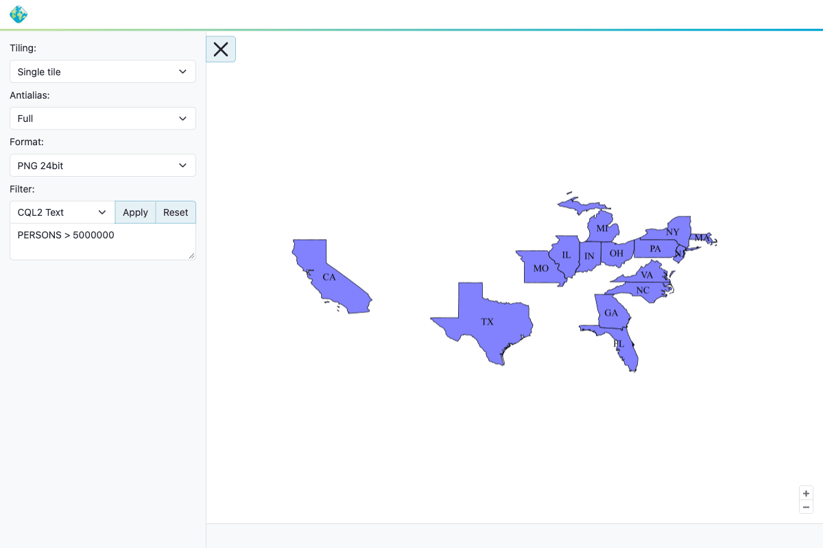
Map preview filtered to the states with more than 5 million inhabitants