NetCDF Output Format
This plugin adds the ability to encode WCS 2.0.1 multidimensional output as a NetCDF file using the Unidata NetCDF Java library.
Getting a NetCDF output file
Request NetCDF output by specifying format=application/x-netcdf in a GetCoverage request:
http://localhost:8080/geoserver/wcs?service=WCS&version=2.0.1&request=GetCoverage&coverageid=it.geosolutions__V&format=application/x-netcdf...
Current limitations
Input coverages/slices should share the same bounding box (lon/lat coordinates are the same for the whole ND cube).
NetCDF output will be produced only when input coverages come from a StructuredGridCoverage2D reader (this allows to query the GranuleSource to get the list of granules in order to setup dimensions slices for each sub-coverage).
NetCDF-4
NetCDF-4 output is supported but requires native libraries (see Installing required NetCDF-4 Native libraries). NetCDF-4 adds support for compression. Use format=application/x-netcdf4 to request NetCDF-4 output.
Settings
NetCDF output settings can be configured for each raster layer. The similar section in the Global Settings page configures the default settings used for newly created raster layers.
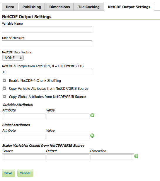
- Variable Name (optional)
Sets the NetCDF variable name.
Does not change the layer name, which can be configured in the Data tab.
- Variable Unit of Measure (optional)
Sets the NetCDF
uomattribute.
- Data Packing
Lossy compression by storing data in reduced precision.
One of NONE, BYTE, SHORT, or INT.
- NetCDF-4 Compression Level
Lossless compression.
Level is an integer from 0 (no compression, fastest) to 9 (most compression, slowest).
- NetCDF-4 Chunk Shuffling
Lossless byte reordering to improve compression.
- Copy Variable Attributes from NetCDF/GRIB Source
Most attributes are copied from the source NetCDF/GRIB variable.
Some attributes such as
coordinatesandmissing_valueare skipped as these may no longer be valid.For an ImageMosaic, one granule is chosen as the source.
- Copy Global Attributes from NetCDF/GRIB Source
Attributes are copied from the source NetCDF/GRIB global attributes.
For an ImageMosaic, one granule is chosen as the source.
- Variable Attributes
Values are encoded as integers or doubles if possible, otherwise strings.
Values set here overwrite attributes set elsewhere, such as those copied from a source NetCDF/GRIB variable.
- Global Attributes
Values are encoded as integers or doubles if possible, otherwise strings.
- Scalar Variables Copied from NetCDF/GRIB Source
Source specifies the name of the source variable in a NetCDF file or the
toolsUIview of a GRIB file; only scalar source variables are supported.Output specifies the name of the variable in the output NetCDF file.
If only one of Source or Output is given, the other is taken as the same.
Dimension is either blank to simply copy the source scalar from one granule, or the name of one output NetCDF dimension to cause values to be copied from multiple granules (such as those from an ImageMosaic over a non-spatial dimension) into a one-dimensional variable. The example above copies a single value from multiple
reftimescalars intoforecast_reference_timedimensioned bytimein an ImageMosaic over time.For an ImageMosaic, one granule is chosen as the source for variable attributes.
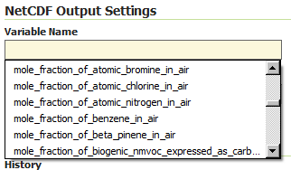
CF Standard names support
Note that the output name can also be chosen from the list of CF Standard names. Check CF standard names page for more info on it.
Once you click on the dropdown, you may choose from the set of available standard names.
NetCDF CF Standard names list
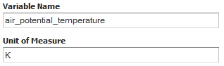
Note that once you specify the standard name, the unit will be automatically configured, using the canonical unit associated with that standard name.
NetCDF CF Standard names and canonical unit
The list of standard names is populated by taking the entries from a standard name table xml. At time of writing, a valid example is available Here
You have three ways to provide it to GeoServer.
Add a
-DNETCDF_STANDARD_TABLE=/path/to/the/table/tablename.xmlproperty to the startup script.Put that xml file within the
NETCDF_DATA_DIRwhich is the folder where all NetCDF auxiliary files are located. (More info)Put that xml file within the
GEOSERVER_DATA_DIR.
Note
Note that for the 2nd and 3rd case, file name must be cf-standard-name-table.xml.