HTML output format
The default HTML output is a sequence of titled tables, each one for a different layer. The following example shows the default output for the tiger-ny basemap (included in the above cited releases, and onwards).
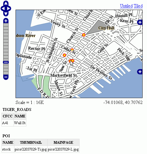
Default Output
Standard Templates
The following assumes you’re already up to speed with FreeMarker templates. If you’re not, read the Freemarker Templates tutorial, and the KML Placemark Templates page, which has simple examples.
The default output is generated by the standard templates, which are three:
header.ftlcontent.ftlfooter.ftl
The header template is invoked just once, and usually contains the start of the HTML page, along with some CSS. The default header template looks like this (as you can see, it’s completely static, and it’s in fact not provided with any variable you could expand):
<#--
Header section of the GetFeatureInfo HTML output. Should have the <head> section, and
a starter of the <body>. It is advised that eventual css uses a special class for featureInfo,
since the generated HTML may blend with another page changing its aspect when using generic classes
like td, tr, and so on.
-->
<html>
  <head>
    <title>GeoServer GetFeatureInfo output</title>
  </head>
  <style type="text/css">
        table.featureInfo, table.featureInfo td, table.featureInfo th {
                border:1px solid #ddd;
                border-collapse:collapse;
                margin:0;
                padding:0;
                font-size: 90%;
                padding:.2em .1em;
        }
        table.featureInfo th{
            padding:.2em .2em;
                text-transform:uppercase;
                font-weight:bold;
                background:#eee;
        }
        table.featureInfo td{
                background:#fff;
        }
        table.featureInfo tr.odd td{
                background:#eee;
        }
        table.featureInfo caption{
                text-align:left;
                font-size:100%;
                font-weight:bold;
                text-transform:uppercase;
                padding:.2em .2em;
        }
  </style>
  <body>
The footer template is similar, a static template used to close the HTML document properly:
<#--
Footer section of the GetFeatureInfo HTML output. Should close the body and the html tag.
-->
  </body>
</html>
The content template is the one that turns feature objects into actual HTML tables. The template is called multiple times: each time it’s fed with a different feature collection, whose features all have the same type. In the above example, the template has been called once for the roads, and once for the points of interest (POI). Here is the template source:
<#--
Body section of the GetFeatureInfo template, it's provided with one feature collection, and
will be called multiple times if there are various feature collections
-->
<table class="featureInfo">
  <caption class="featureInfo">${type.name}</caption>
  <tr>
<#list type.attributes as attribute>
  <#if !attribute.isGeometry>
    <th >${attribute.name}</th>
  </#if>
</#list>
  </tr>

<#assign odd = false>
<#list features as feature>
  <#if odd>
    <tr class="odd">
  <#else>
    <tr>
  </#if>
  <#assign odd = !odd>

  <#list feature.attributes as attribute>
    <#if !attribute.isGeometry>
      <td>${attribute.value}</td>
    </#if>
  </#list>
  </tr>
</#list>
</table>
<br/>
As you can see, there is a first loop scanning type and outputting its attributes into the table header, then a second loop going over each feature in the collection (features). From each feature, the attribute collections are accessed to dump the attribute value. In both cases, geometries are skipped, since there is not much point in including them in the tabular report. In the table building code you can also see how odd rows are given the “odd” class, so that their background colors improve readability.
Custom Templates
So, what do you have to do if you want to override the custom templates? Well, it depends on which template you want to override.
header.ftl and footer.ftl are type independent, so if you want to override them you have to place a file named header.ftl or footer.ftl in the templates directory, located in your GeoServer GeoServer data directory. On the contrary, content.ftl may be generic, or specific to a feature type.
For example, let’s say you would prefer a bulleted list appearance for your feature info output, and you want this to be applied to all GetFeatureInfo HTML output. In that case you would drop the following content.ftl in the templates directory:
<ul>
<#list features as feature>
  <li><b>Type: ${type.name}</b> (id: <em>${feature.fid}</em>):
  <ul>
  <#list feature.attributes as attribute>
    <#if !attribute.isGeometry>
      <li>${attribute.name}: ${attribute.value}</li>
    </#if>
  </#list>
  </ul>
  </li>
</#list>
</ul>
With this template in place, the output would be:
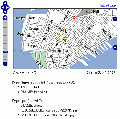
Bulleted List Output
Looking at the output we notice that point of interest features refer to image files, which we know are stored inside the default GeoServer distribution in the demo_app/pics path. So, we could provide a POI specific override that actually loads the images.
This is easy: just put the following template in the feature type folder, which in this case is workspaces/topp/DS_poi/poi (you should refer to your Internet visible server address instead of localhost, or its IP if you have fixed IPs):
<ul>
<#list features as feature>
  <li><b>Point of interest, "${feature.NAME.value}"</b>: <br/>
  <img src="http://localhost:8080/geoserver/popup_map/${feature.THUMBNAIL.value}"/>
  </li>
</#list>
</ul>
With this additional template, the output is:
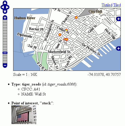
Output with Thumbnail Image
As you can see, roads are still using the generic template, whilst POI is using its own custom template.
Advanced Formatting
The value property of Feature attribute values are given by geoserver in String form, using a sensible default depending on the actual type of the attribute value. If you need to access the raw attribute value in order to apply a custom format (for example, to output "Enabled" or "Disabled" for a given boolean property, instead of the default true/false, you can just use the rawValue property instead of value. For example: ${attribute.rawValue?string("Enabled", "Disabled")} instead of just ${attribute.value}.
Auto-Escaping
Auto-escaping can be used to escape special characters so that they are displayed correctly in clients and to prevent injection. GeoServer administrators can enable or disable auto-escaping for FreeMarker template values for the HTML output format on a global or per virtual service basis. Template authors are able to override the WMS service setting to enable or disable escaping on a per template, per block or per value basis. See Auto-escaping for more information.
Content Security Policy
The Content-Security-Policy header will block unsafe JavaScript by default. In order to allow
'unsafe-inline' and 'unsafe-eval' scripts or loading font, image, style or script resources
from remote hosts, the GEOSERVER_FEATUREINFO_HTML_SCRIPT property can be set either via Java
system property, command line argument (-D), environment variable or web.xml init parameter. The
property can be set to either SELF or UNSAFE with SELF being the default value.
See Content Security Policy for instructions to modify the CSP header if it is continuing to block
certain functionality of custom HTML templates even with the UNSAFE property.
Warning
Allowing unsafe scripts could allow cross-site scripting attacks and should only be done if you can fully trust your template authors.
Accessing Instance Methods
Access to instance methods in FreeMarker templates is controlled by a block list, an allow list, and a boolean flag that restricts access to only getter methods.
The block list contains a list of classes and packages and blocks access to a method if either the
template object’s class or the method’s return type is in the block list. The default block list
contains classes that are known to provided sensitive functionality and the
GEOSERVER_FREEMARKER_BLOCK_LIST system property can be set to block additional classes and
packages. The default block list is:
java.io.InputStreamjava.io.OutputStreamjava.lang.Classjava.lang.ClassLoaderjava.lang.reflect.InvocationHandlerjava.lang.reflect.java.security.org.geoserver.catalog.Catalogorg.geoserver.platform.resource.ResourceStoreorg.geotools.api.data.DataAccessorg.geotools.api.coverage.grid.GridCoverageReaderorg.geotools.api.coverage.grid.GridCoverageWriter
The allow list contains a list of classes and packages and allows access to a method if both the
template object’s class and the method’s return type are either a primitive type (e.g., int) or
in the allow list. The default allow list allows access to JDK, GeoServer, GeoTools and JTS geometry
classes and the GEOSERVER_FREEMARKER_ALLOW_LIST system property can be set to allow additional
classes and packages. The default allow list is:
java.javax.xml.namespace.QNamenet.opengis.org.geoserver.org.geotools.org.locationtech.jts.geom.
Note
A class must be both in the allow list and not in the block list to be allowed and it is not possible to use the system properties to allow a class that is in the default block list.
The GEOSERVER_FREEMARKER_BLOCK_LIST and GEOSERVER_FREEMARKER_ALLOW_LIST properties allow a
comma-separated list of class names and package name prefixes. For example, when specifying
-DGEOSERVER_FREEMARKER_BLOCK_LIST=org.geoserver.catalog.MetadataMap,org.geotools.api.util., the
class org.geoserver.catalog.MetadataMap and all classes in the package org.geotools.api.util
will be blocked for use in templates.
An additional security precaution, that is enabled by default, restricts access to only getter
methods (e.g., getTitle, isEnabled). Templates should be accessing these as Java Bean
properties (e.g., object.title) rather than calling the method directly even though that is
allowed. The GEOSERVER_FREEMARKER_API_EXPOSED system property can be set to true to allow
access to all instance methods that pass the allow and block list checks. While the default allow
and block lists should be sufficient to prevent malicious templates from causing any significant
impact to GeoServer, this feature will help protect against future GeoServer enhancements exposing
sensitive functionality to templates.
Note
The MapML, OGC API and OpenSearch for EO extension and community modules require access to non-getter methods in their FreeMarker templates for backwards-compatibility and are not affected by that setting but the class restrictions apply to all templates.
Accessing static methods
It is possible to call static methods and variables from within Freemarker templates to enable more sophisticated templates.
But please be aware that generally static method calls are a security liability, which can be used to make harmful things, especially when template authors can not be fully trusted. So by default this feature is disabled. The configuration parameter org.geoserver.htmlTemplates.staticMemberAccess has to specified to enabled it, for example as system property. The parameter takes a comma separated list of fully qualified class names. GeoServer allows access to static member of these classes from within templates using their simple, unqualified class name as the example below demonstrates.
The following system property enables selective access:
-Dorg.geoserver.htmlTemplates.staticMemberAccess=java.lang.String
This exposes the static members of java.lang.String using the variable name String in the template, which can be used in templates as follows:
<ul>
<#list features as feature>
  <li>${feature.NAME.value}: ${String.format("%.2f €", feature.AMOUNT.rawValue)}
  </li>
</#list>
</ul>
In case of granting access to multiple classes with the same simple name, the later specified classes will be exposed with a number suffix. For example when specifying -Dorg.geoserver.htmlTemplates.staticMemberAccess=java.lang.String,com.acme.String, the statics of java.lang.String will be exposed as String while the statics of com.acme.String will be exposed as String2 and so on.
You can also enable unrestricted access by specifying a * as the next example demonstrates.
The following system property enables unrestricted access:
-Dorg.geoserver.htmlTemplates.staticMemberAccess=*
In this case GeoServer exposes a statics variable you can use in templates to access static members as follows:
<#assign String=statics['java.lang.String']>
<ul>
<#list features as feature>
  <li>${feature.NAME.value}: ${String.format("%.2f €", feature.AMOUNT.rawValue)}
  </li>
</#list>
</ul>
Warning
Unrestricted access as shown above is only recommended if you can fully trust your template authors.