GeoRSS
GeoServer supports GeoRSS as an output format allowing you to serve features as an RSS feed.
Quick Start
If you are using a web browser which can render RSS feeds simply visit the URL http://localhost:8080/geoserver/wms/reflect?layers=states&format=rss in your browser. This is assuming a local GeoServer instance is running with an out of the box configuration. You should see a result that looks more or less like this:
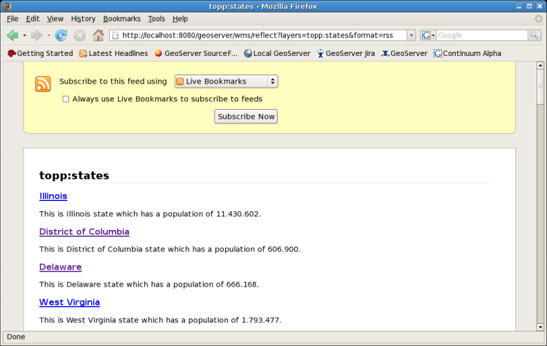
topp:states rss feed
Templating
GeoServer uses FreeMarker templates to customize the returned GeoRSS feed. If you are not familiar with FreeMarker templates you may wish to read the Freemarker Templates tutorial, and the KML Placemark Templates page, which has simple examples.
Three template files are currently supported:
title.ftldescription.ftllink.ftl
Each of these files may be used to customize the associated field in the GeoRSS feed.
Ajax Map Mashups
Note
For Ajax map mashups to work, the GeoServer instance must be visible to the Internet (i.e. using the address localhost will not work).
Google Maps
How to create a Google Maps mashup with a GeoRSS overlay produced by GeoServer.
Obtain a Google Maps API Key from Google.
Create an html file called
gmaps.html:<!DOCTYPE html PUBLIC "-//W3C//DTD XHTML 1.0 Strict//EN" "http://www.w3.org R/xhtml1/DTD/xhtml1-strict.dtd"> <html xmlns="http://www.w3.org/1999/xhtml"> <head> <meta http-equiv="content-type" content="text/html; charset=utf-8"/> <title>Google Maps JavaScript API Example< itle> <script src="http://maps.google.com/maps?file=api&v=2.x&key=<INSERT MAPS API KEY HERE>" type="text/javascript"></script> <script type="text/javascript"> //<![CDATA[ function load() { if (GBrowserIsCompatible()) { var map = new GMap2(document.getElementById("map")); map.addControl(new GLargeMapControl()); map.setCenter(new GLatLng(40,-98), 4); var geoXml = new GGeoXml("<INSERT GEOSERVER URL HERE>/geoserver/wms/reflect?layers=states&format=rss"); map.addOverlay(geoXml); } } //]]> </script> </head> <body onload="load()" onunload="GUnload()"> <div id="map" style="width: 800px; height: 600px"></div> </body> </html>Visit
gmaps.htmlin your web browser.
Note
The version of the google maps api must be 2.x, and not just 2 You must insert your specific maps api key, and geoserver base url
Yahoo Maps
How to create a Yahoo! Maps mashup with a GeoRSS overlay produced by GeoServer.
Obtain a <Yahoo Maps Application ID <http://search.yahooapis.com/webservices/register_application>`_ from Yahoo.
Create an html file called
ymaps.html:<html> <head> <title>Yahoo! Maps GeoRSS Overlay Example< itle> <script src="http://api.maps.yahoo.com/ajaxymap?v=3.0&appid=<INSERT APPLICATION ID HERE>" type="text/javascript"></script> <script type="text/javascript" language="JavaScript"> function StartYMap() { var map = new YMap(document.getElementById('ymap')); map.addPanControl(); map.addZoomShort(); function doStart(eventObj) { var defaultEventObject = eventObj; //eventObj.ThisMap [map object] //eventObj.URL [argument] //eventObj.Data [processed input] } function doEnd(eventObj) { var defaultEventObject = eventObj; //eventObj.ThisMap [map object] //eventObj.URL [argument] //eventObj.Data [processed input] map.smoothMoveByXY(new YCoordPoint(10,50)); } YEvent.Capture(map,EventsList.onStartGeoRSS, function(eventObj) { doStart(eventObj); }); YEvent.Capture(map,EventsList.onEndGeoRSS, function(eventObj) { doEnd(eventObj); }); map.addOverlay(new YGeoRSS('http://<INSERT GEOSERVER URL HERE>/geoserver/wms/reflect?layers=states&format=rss')); } window.onload = StartYMap; </script> </head> <body> <div id="ymap" style="width: 800px; height: 600px; left:2px; top:2px"></div> </body> </html>Visit
ymaps.htmlin your web browser.
Note
The version of the yahoo maps api must be 3.0 You must insert your specific application id, and geoserver base url
Microsoft Virtual Earth
Note
Non Internet Explorer Users*: GeoRSS overlays are only supported in Internet Explorer, versions greater than 5.5.
How to create a Microsoft Virtual Earth mashup with a GeoRSS overlay produced by GeoServer.
Note
To access a GeoRSS feed from Microsoft Virtual Earth the file (ve.html) must be accessed from a Web Server, IE. It will not work if run from local disk.
Create an html file called
ve.html. Note: You must insert your specific maps api key, and geoserver base url:<html> <head> <script src="http://dev.virtualearth.net/mapcontrol/v4/mapcontrol.js"></script> <script> var map; function OnPageLoad() { map = new VEMap('map'); map.LoadMap(); var veLayerSpec = new VELayerSpecification(); veLayerSpec.Type = VELayerType.GeoRSS; veLayerSpec.ID = 'Hazards'; veLayerSpec.LayerSource = 'http://<INSERT GEOSERVER URL HERE>/geoserver/wms/reflect?layers=states&format=rss'; veLayerSpec.Method = 'get'; map.AddLayer(veLayerSpec); } </script> </head> <body onload="OnPageLoad();"> <div id="map" style="position:relative;width:800px;height:600px;"></div> </body> </html>
Visit
ve.htmlin your web browser. You should see the following:
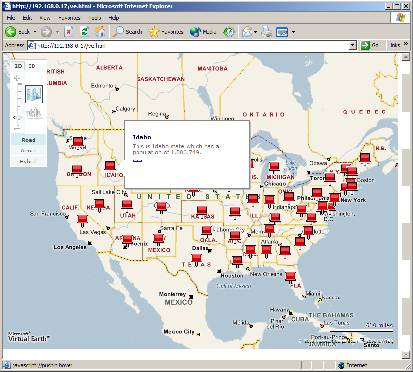
Virtual Earth