Installation
Visit the website download page, locate your release, and download: geoserver-2.26.x-mapml-plugin.zip
Warning
Make sure to match the version of the extension (for example 2.26-SNAPSHOT above) to the version of the GeoServer instance!
Extract the contents of the archive into the
WEB-INF/libdirectory of the GeoServer installation.Restart GeoServer.
Configuration
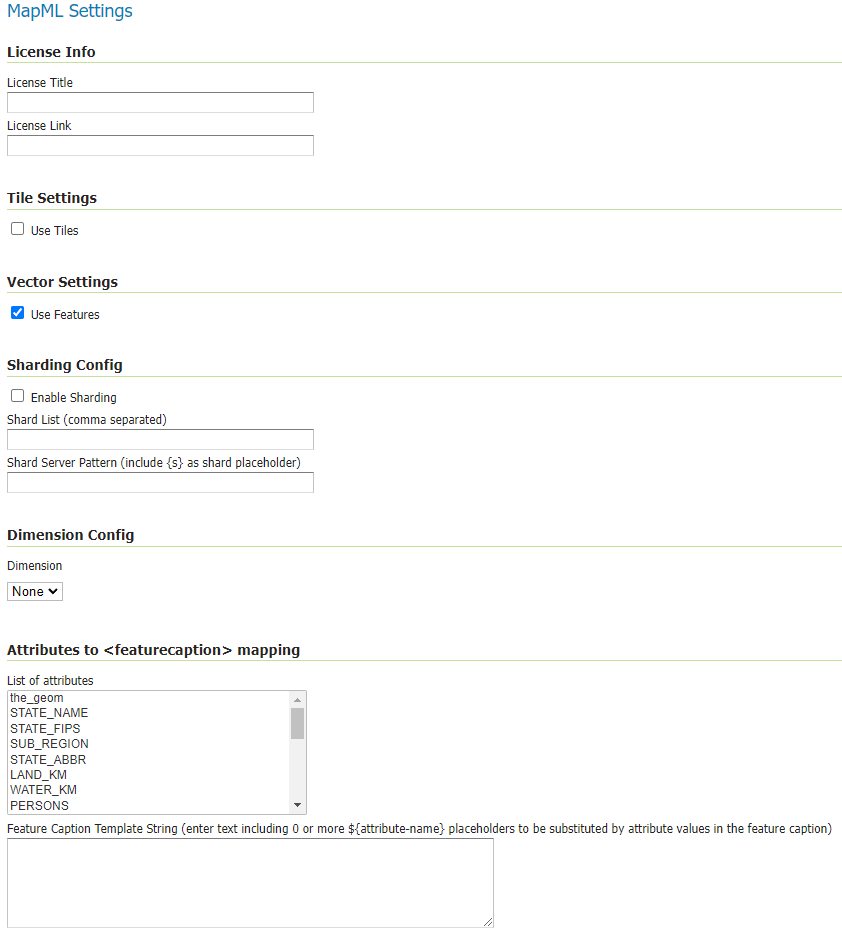
Configuration can be done using the Geoserver administrator GUI. The MapML configuration is accessible in the MapML Settings section under the Publishing tab of the Layer or Layer Group Configuration page for the layer or layer group being configured. Here is the MapML Settings section, with some example values filled in:
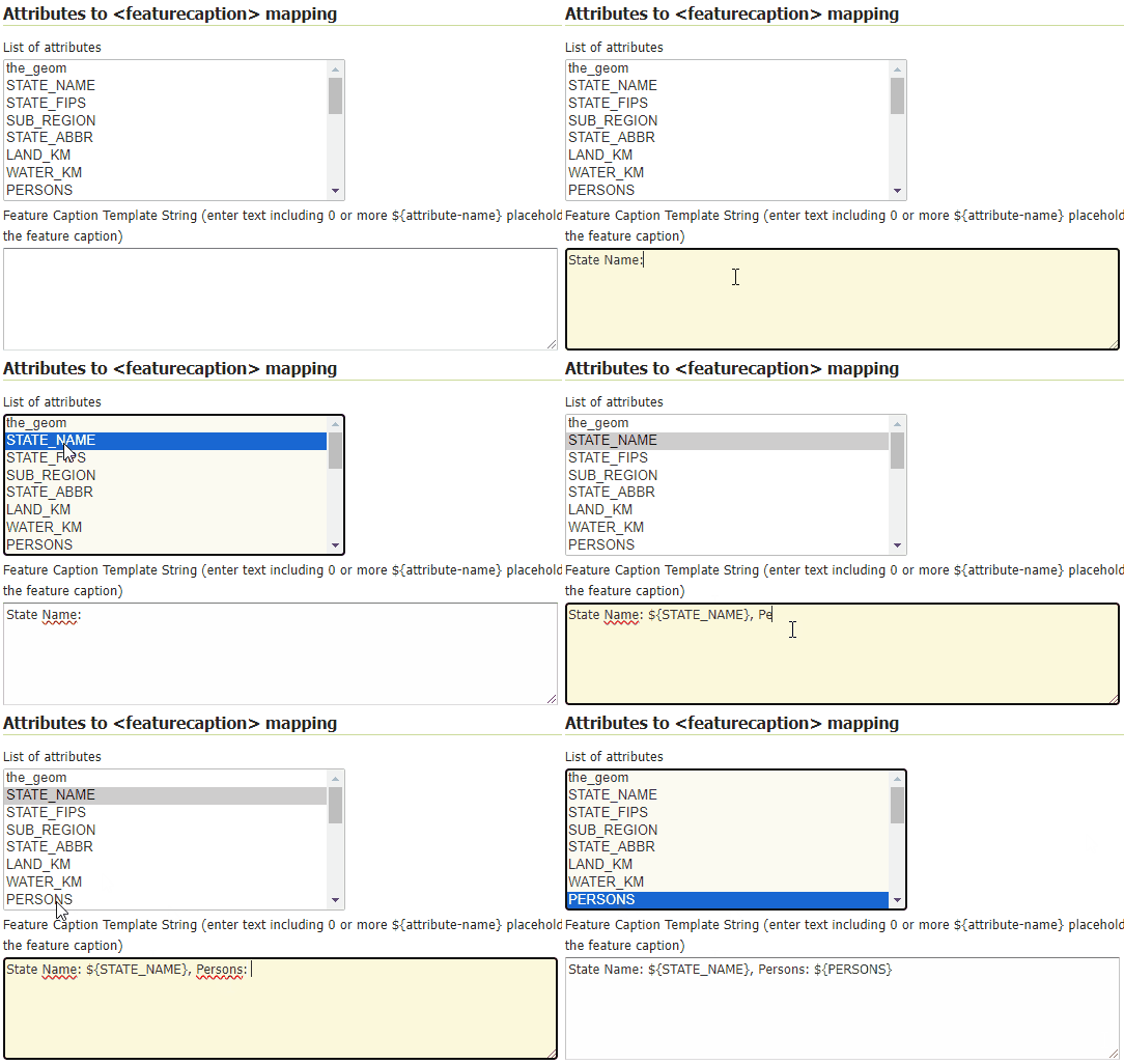
Attributes to <feature caption> mapping section allows to define a template so that feature caption can include attribute values. Double clicking on one entry of the List of Attributes, will append an ${attribute} placeholder at the end of the Feature Caption Template String text area.
For example, for the State layer, you can define a template showing the State Name and the number of persons, by following these steps:
Write “State Name:” on the text area
Double click on the STATE_NAME attribute from the list of attributes, which will result in appending the ${STATE_NAME} placeholder to the previous text.
Continue writing “, Persons:” on the text area
Double click on the PERSONS attribute from the list of attributes, which will result in appending the ${PERSONS} placeholder to the previous text.
See the following gif showing the result.
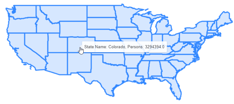
After having saved the configuration, the WFS output will looks like this, where on mouseover, you can see the feature caption being setup on top of the defined template:
There is also a MapML-specific global WMS setting in the MapML Extension section of the WMS Services Settings Page. This setting is used to control the handling of multi-layer requests.
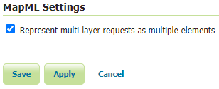
If the Represent multi-layer requests as multiple elements is checked (and the configuration is saved), an individually accessible <map-extent> element will be generated for each requested layer. The default is to represent the layers as a single (hidden) <map-extent>.
Styles
Like any WMS layer or layer group available from GeoServer, a comma-separated list of styles may be supplied in the WMS GetMap styles parameter. If no style name is requested, the default style will be used for that layer. For single-layer or single-layer group requests, the set of alternate styles is presented as an option list in the layer preview map’s layer control, with the currently requested style indicated.
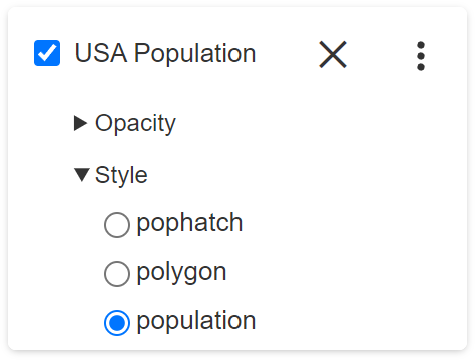
Note that in order to ensure that the default layer style is properly available to the preview map’s option list, make sure that the style is moved to the Available Styles list in the Publishing tab of the Layer Configuration page. If the style is set to Default but not explicitly made Available, the style will not be available to MapML. Similarly but a with a slight variation in requirement, for Layer Groups, the ‘default’ layer group style must be copied and given a name matching default-style- plus the layer group name.
License Info
Together these two attributes allow the administrator to define the contents of the <link rel=license> element in the MapML header. Here is an example of the resulting XML:
<link href=”https://creativecommons.org/licenses/by/4.0/” rel=”license” title=”Attribution 4.0 International (CC BY 4.0)”/>
- License Title
The License Title will be included as the value of
titleattribute of the<link rel=license>element in the MapML header.- License Link
The License Link will be included as the value of
hrefattribute of the<link rel=license>element in the MapML header, and should be a valid URL referencing the license document.
Tile Settings
Using tiles to access the layer can increase the performance of your web map. This is especially true if there is a tile cache mechanism in use between GeoServer and the browser client.
- Use Tiles
If the “Use Tiles” checkbox is checked, by default the output MapML will define a tile-based reference to the WMS server. Otherwise, an image-based reference will be used. If one or more of the MapML-defined GridSets is referenced by the layer or layer group in its “Tile Caching” profile, GeoServer will generate tile references instead of generating WMS GetMap URLs in the MapML document body.
Client Requests
When configuring a cascaded WMS or WMTS remote layers, a new “Client Requests” setting is available.
- Remote
If the “Remote” checkbox is checked, the link templates embedded in MapML will refer to the remote WMS/WMTS. The MapML viewer will directly contact the remote server if certain criteria are met:
No restricting DataAccessLimit security is associated to the layer (e.g. with GeoFence integration) that will do filtering, clipping or similar operations. In that case, the MapML will point to the local GeoServer so that the param is honored.
No vendor parameters are used in the incoming request. If vendor parameters are used (e.g., request clipping with geometric mask) the MapML is pointing to the local GeoServer so that the vendor parameter is honored
The remote Server is supporting the requested CoordinateReferenceSystem for that layer.
GetTile requests will be sent to the remote server if there is a compatible gridset for that layer (same origin, same CRS, same tile sizes, same levels and same resolutions)
Vector Settings
MapML supports the serving of vector feature representations of the data. This results in a smoother user navigation experience, smaller bandwidth requirements, and more options for dynamic styling on the client-side.
- Use Features
If the “Use Features” checkbox is checked, by default the output MapML will define a feature-based reference to the WMS server. Otherwise, an image-based reference will be used. Note that this option is only available for vector source data. MapML <map-extent> element with a feature link:
<map-extent units="WGS84" label="Manhattan (NY) points of interest" checked="checked">
<map-input name="z" type="zoom" min="0" max="21"/>
<map-input name="xmin" type="location" rel="map" position="top-left" axis="longitude" units="gcrs" min="-74.0118315772888" max="-74.00153046439813"/>
<map-input name="ymin" type="location" rel="map" position="bottom-left" axis="latitude" units="gcrs" min="40.70754683896324" max="40.719885123828675"/>
<map-input name="xmax" type="location" rel="map" position="top-right" axis="longitude" units="gcrs" min="-74.0118315772888" max="-74.00153046439813"/>
<map-input name="ymax" type="location" rel="map" position="top-left" axis="latitude" units="gcrs" min="40.70754683896324" max="40.719885123828675"/>
<map-input name="w" type="width" min="1" max="10000"/>
<map-input name="h" type="height" min="1" max="10000"/>
<map-link tref="http://localhost:8080/geoserver/tiger/wms?format_options=mapmlfeatures:true&request=GetMap&crs=MapML:WGS84&bbox={xmin},{ymin},{xmax},{ymax}&format=text/mapml&language=en&version=1.3.0&transparent=true&service=WMS&layers=poi&width={w}&styles=&height={h}" rel="features"/>
</map-extent>
When both “Use Tiles” and “Use Features” are checked, the MapML extension will request tiled maps in text/mapml format.
The contents of the tiles will be clipped to the requested area, and feature attributes will be skiipped, as the MapML client cannot leverage them for the moment.
- Feature Styling
Basic styling of vector features is supported by the MapML extension. The style is defined in the WMS GetMap request, and the MapML extension will convert the rules and style attributes defined in the SLD into CSS classes and apply those classes to the appropriate features. Note that this conversion is currently limited to basic styling and does not include transformation functions, external graphics, or styling dependent on individual feature attributes (non-static style values). See below for a more detailed compatibility table:
Symbolizer |
Style Attribute |
Supported |
|---|---|---|
PointSymbolizer |
Opacity |
yes |
Default Radius |
yes |
|
Radius |
yes |
|
Rotation |
no |
|
Displacement |
no |
|
Anchor Point |
no |
|
Gap |
no |
|
Initial Gap |
no |
|
Well Known Name |
yes |
|
External Mark |
no |
|
Graphic Fill |
no |
|
Fill Color |
yes |
|
Fill Opacity |
yes |
|
Stroke Color |
yes |
|
Stroke Opacity |
yes |
|
Stroke Width |
yes |
|
Stroke Linecap |
yes |
|
Stroke Dash Array |
yes |
|
Stroke Dash Offset |
yes |
|
Stroke Line Join |
no |
|
LineSymbolizer |
Stroke Linecap |
yes |
Stroke Dash Array |
yes |
|
Stroke Dash Offset |
yes |
|
Stroke Line Join |
no |
|
PolygonSymbolizer |
Displacement |
no |
Perpendicular Offs |
no |
|
Graphic Fill |
no |
|
Fill Color |
yes |
|
Fill Opacity |
yes |
|
Stroke Color |
yes |
|
Stroke Opacity |
yes |
|
Stroke Width |
yes |
|
Stroke Linecap |
yes |
|
Stroke Dash Array |
yes |
|
Stroke Dash Offset |
yes |
|
Stroke Line Join |
no |
|
TextSymbolizer |
ALL |
no |
RasterSymbolizer |
ALL |
no |
Transformation Functions |
ALL |
no |
Zoom Denominators |
ALL |
yes |
WMS GetMap considerations
By default, each layer/style pair that is requested via the GetMap parameters is composed into a single <map-extent>…<map-link tref=”…”>…</map-extent> structure as exemplified above.
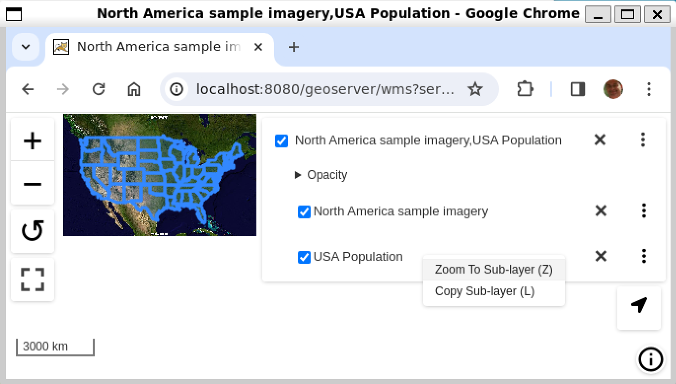
If the ‘Represent multi-layer requests as multiple elements’ checkbox from the global WMS Settings page is checked as described above, a request for multiple layers or layer groups in MapML format will result in the serialization of a MapML document containing multiple <map-extent> elements. Each layer/style pair is represented by a <map-extent> element in the response. The <map-extent> elements are represented in the client viewer layer control settings as sub-layers, which turn on and off independently of each other, but which are controlled by the parent <map-layer> element’s state (checked / unchecked, opacity etc) (right-click or Shift+F10 to obtain context menus):

With ‘Represent multi-layer requests as multiple elements’ checked, if two or more layers are requested in MapML format via the GetMap ‘layers’ parameter, the MapML extension serialize each layer’s <map-extent> according to its “Use Features” and “Use Tiles” settings. Note that there is currently no “Use Features” setting available for layer groups.
Tile Caching
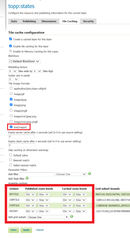
In the Tile Caching tab panel of the Edit Layer or Edit Layer Group page, at the bottom of the page you will see the table of GridSets that are assigned to the layer or layer group.
The values WGS84 and OSMTILE are equivalent to the EPSG:4326 and EPSG:900913 built in GeoWebCache GridSets.
However, for the MapML module to recognize these GridSets, you must select and use the MapML names. For new layers or layer groups, or newly created grid subsets for a layer or layer group, the MapML values are selected by default. For existing layers that you wish to enable the use of cached tile references by the MapML service, you will have to select and add those values you wish to support from the dropdown of available GridSets. The set of recognized values for MapML is WGS84 (equivalent to EPSG:4326), OSMTILE (equivalent to EPSG:900913), CBMTILE (Canada Base Map) and APSTILE (Alaska Polar Stereographic).
The MapML client will normally request image tiles against WMTS, but if configured to use feature output,
it will try to use tiles in text/mapml format, which should be configured as a cacheable format
in order to enable WMTS requests.
Starting with version 2.26.x of GeoServer, Sharding support and related configuration has been removed
Dimension Config
- Dimension
The selected dimension (if any) is advertised in the mapml as an input with the appropriate value options or ranges, as configured in the Dimension tab of the Layer Configuration page. Only dimensions enabled in the Dimension tab are available as options.
Attribute to <featurecaption> mapping
List of attributes The list allows you to read the names of the layer attributes, it doesn’t really do more than that.
Feature Caption Template String
To cause an attribute to be serialized in MapML vector content as the <featurecaption> element value, you must enter its name as a ${placeholder} in the text box immediately below the attributes list. You can also add (a small amount of) plain text that will be copied verbatim into the <featurecaption> content. <featurecaption> is used as the accessible name of features by screen reader software, which will often read out this value without the user having to expand a popup; in other words, it will be used as a visual and audible tooltip when the feature is focused.
MapML Resources
MapML resources will be available for any published WMS layers by making a GetMap request with the WMS output format to format=text/mapml. See Web Map Service (WMS) for further WMS details, GetMap for GetMap details, and WMS output formats for output format reference information.
SRS/CRS
Note that the WMS SRS or CRS must be one of the projections supported by MapML:
MapML:WGS84 (or EPSG:4326)
MapML:OSMTILE (or EPSG:3857)
MapML:CBMTILE (or EPSG:3978)
MapML:APSTILE (or EPSG:5936)
The equivalent EPSG codes are provided for reference, but the MapML names are recommended, as they imply not only a coordinate refefence system, but also a tile grid and a set of zoom levels (Tiled CRS), that the MapML client will use when operating in tiled mode. When using tiles, it’s also recommended to set up tile caching for the same-named gridsets.
If the native SRS of a layer is not a match for the MapML ones, remember to configure the projection policy to “reproject native to declare”. You might have to save and reload the layer configuration in order to re-compute the native bounds correctly.
If the SRS or CRS is not one of the above, the GetMap request will fail with an InvalidParameterValue exception.
The main “MapML” link in the preview page generates a HTML client able to consume MapML resources.
The link is generated so that it always work, if the CRS configured for the layer is not supported, it will automatically fall back on MapML:WGS84.
MapML Output Format
The output image format for the MapML resource should be specified using the format_options parameter with a key called mapml-wms-format. If provided, the provided mime type must be a valid WMS format specifier. If not provided, it defaults to image/png.
Example:
http://localhost:8080/geoserver/tiger/wms?service=WMS&version=1.1.0&request=GetMap&layers=tiger:giant_polygon&bbox=-180.0,-90.0,180.0,90.0&width=768&height=384&srs=EPSG:4326&styles=&format=text/mapml&format_options=mapml-wms-format:image/jpeg
MapML Visualization
With the MapML Extension module installed, the GeoServer Layer Preview page is modified to add a WMS GetMap link to the MapML resources for each layer or layer group. The MapML link in the Layer Preview table is generated by the MapML extension to an HTML Web map page that is created on the fly which refers to the GeoServer resource:
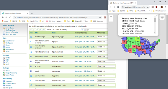
You can add layers to the map as you like, by dragging the URL bar value generated by the Layer Preview WMS formats dropdown menu selection of “MapML” as shown below, and dropping it onto another layer’s MapML preview:
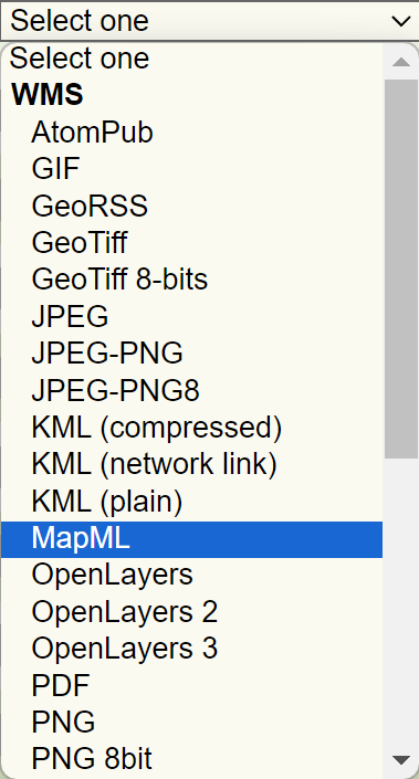
If all goes well, you should see the layers stacked on the map and in the layer control.
MapML visualization is supported by the MapML.js project. The MapML viewer is built into the GeoServer layer and layer group preview facility. You can find out more about MapML.js at the project website <https://maps4html.org/web-map-doc/>. Here is a simple, self-contained example of an HTML page that uses the <mapml-viewer> and <map-layer> elements:
<!DOCTYPE html>
<html lang="en">
  <head>
    <meta charset="utf-8" >
    <title>MapML Test Map</title>
    <meta name="viewport" content="width=device-width, initial-scale=1">
    <script type="module" src="http://localhost:8080/geoserver/mapml/viewer/widget/mapml-viewer.js"></script>
    <style>
      html, body { height: 100%; }
      * { margin: 0; padding: 0; }
      mapml-viewer:defined { max-width: 100%; width: 100%; height: 100%; }
      mapml-viewer:not(:defined) > * { display: none; } map-layer { display: none; }
    </style>
  </head>
  <body>
    <mapml-viewer projection="osmtile" zoom="2" lat="61.209125" lon="-90.850837" controls>
      <map-layer label="US States" src="http://localhost:8080/geoserver/mapml/topp:states/osmtile?style=population" checked></map-layer>
    </mapml-viewer>
  </body>
</html>
In the above example, the place-holders topp:states, localhost:8080, osmtile, and population would need to be replaced with the appropriate values, and/or the style parameter could be removed entirely from the URL if not needed. You may also like to “View Source” on the preview page to see what the markup looks like for any layer. This code can be copied and pasted without harm, and you should try it and see what works and what the limitations are. For further information about MapML, and the Maps for HTML Community Group, please visit http://maps4html.org.
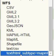
In addition the MapML viewer is also available as output of a WFS GetFeature request. Select the text/html; subtype=mapml from the dropdown as shown below:
Warning
Note that the MapML WFS output will automatically set a default max feature limit. Removing that limit can lead to browser issues.