PostGIS

PostGIS is an open source spatial database based on PostgreSQL, and is currently one of the most popular open source spatial databases today.

Adding a PostGIS database

As with all formats, adding a shapefile to GeoServer involves adding a new store to the existing Stores through the Web administration interface.

Using default connection

To begin, navigate to Stores ‣ Add a new store ‣ PostGIS NG.

Fill in the Basic Store Info used to identify the database when managing layers.

../../_images/postgis-basic-info.png

Adding a PostGIS database

Basic Store Info

Description

Workspace

Name of the workspace to contain the database. This will also be the prefix of any layer names created from tables in the database.

Data Source Name

Name of the database. This can be different from the name as known to PostgreSQL/PostGIS.

Description

Description of the database/store.

Enabled

Enables the store. If disabled, no data in the database will be served.

Move on to the connection parameters used to connect and interact with the database.

../../_images/postgis.png

PostGIS connection parameters

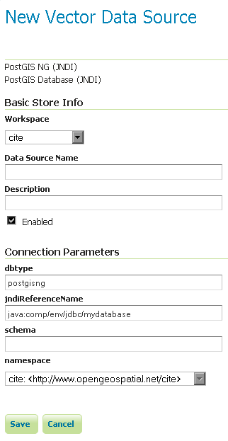
The dbtype and namespace connection parameters are not directly editable. The dbtype parameter is for internal use only (and only accessible via the REST API).

Connection Parameter

Description

dbtype

Type of database. Internal value, leave this value as the default.

namespace

Namespace to be associated with the database. This field is altered by changing the workspace name.

Connection parameters establishing a database connection (see Database Connection Pooling):

Connection Parameter

Description

host

Host name where the database exists.

port

Port number to connect to the above host.

database

Name of the database as known on the host.

schema

Schema in the above database.

user

Username to connect to the database.

passwd

Password associated with the above user.

max connections

Maximum amount of open connections to the database.

min connections

Minimum number of pooled connections.

fetch size

Number of records read with each interaction with the database.

Connection timeout

Time (in seconds) the connection pool will wait before timing out.

validate connections

Checks the connection is alive before using it.

Evictor run periodicity

Number of seconds between idle object evictor runs.

Max connection idle time

Number of seconds a connection needs to stay idle before the evictor starts to consider closing it.

Evictor tests per run

Number of connections checked by the idle connection evictor for each of its runs.

Connection parameters managing SQL generation:

Connection Parameter

Description

Expose primary keys

Expose primary key columns as values suitable for filtering.

Primary key metadata table

Provide table defining how primary keys values are generated (see Controlling feature ID generation in spatial databases)

Session startup SQL

SQL applied to connection before use (see Custom SQL session start/stop scripts)

Session close-up SQL

SQL applied to connection after use (see Custom SQL session start/stop scripts)

preparedStatements

Enables prepared statements for SQL generation, rather than text substitution.

Max open prepared statements

Number of prepared statements available.

Connection parameters managing database interaction:

Connection Parameter

Description

Loose bbox

Performs only the primary filter on the bounding box. See the section on Using loose bounding box for details.

Estimated extends

Use spatial index to quickly estimate bounds, rather than check every row.

Encode functions

Generate supported filter functions into their SQL equivalent.

Support on the fly geometry simplification

Enables use of PostGIS geometry simplification

Connection parameters supporting initial database creation:

Connection Parameter

Description

create database

Enable to define a new database on connection

create database params

Additional CREATE DATABASE definition, example WITH TEMPLATE=postgis

When finished, click Save.

Using JNDI

GeoServer can also connect to a PostGIS database using JNDI (Java Naming and Directory Interface).

To begin, navigate to Stores ‣ Add a new store ‣ PostGIS NG (JNDI).

../../_images/postgisjndi.png

Adding a PostGIS database (using JNDI)

Option

Description

Workspace

Name of the workspace to contain the store. This will also be the prefix of all of the layer names created from the store.

Data Source Name

Name of the database. This can be different from the name as known to PostgreSQL/PostGIS.

Description

Description of the database/store.

Enabled

Enables the store. If disabled, no data in the database will be served.

dbtype

Type of database. Leave this value as the default.

jndiReferenceName

JNDI path to the database.

schema

Schema for the above database.

namespace

Namespace to be associated with the database. This field is altered by changing the workspace name.

When finished, click Save.

Configuring PostGIS layers

When properly loaded, all tables in the database will be visible to GeoServer, but they will need to be individually configured before being served by GeoServer. See the section on Layers for how to add and edit new layers.

Using loose bounding box

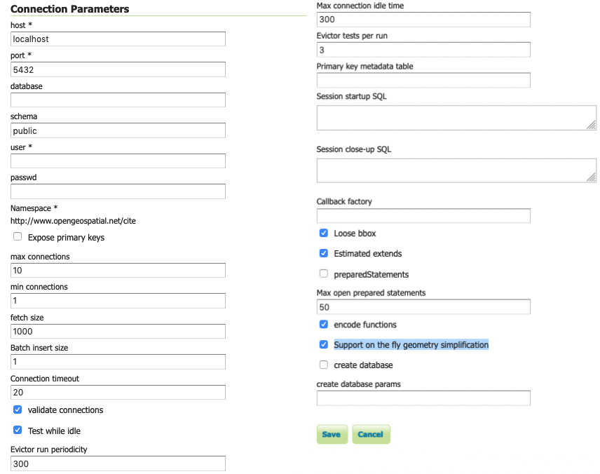
When the option loose bbox is enabled, only the bounding box of a geometry is used. This can result in a significant performance gain, but at the expense of total accuracy; some geometries may be considered inside of a bounding box when they are technically not.

If primarily connecting to this data via WMS, this flag can be set safely since a loss of some accuracy is usually acceptable. However, if using WFS and especially if making use of BBOX filtering capabilities, this flag should not be set.

Publishing a PostGIS view

Publishing a view follows the same process as publishing a table. The only additional step is to manually ensure that the view has an entry in the geometry_columns table.

For example consider a table with the schema:

my_table( id int PRIMARY KEY, name VARCHAR, the_geom GEOMETRY )

Consider also the following view:

CREATE VIEW my_view as SELECT id, the_geom FROM my_table;

Before this view can be served by GeoServer, the following step is necessary to manually create the geometry_columns entry:

INSERT INTO geometry_columns VALUES ('','public','my_view','my_geom', 2, 4326, 'POINT' );

Performance considerations

GEOS

GEOS (Geometry Engine, Open Source) is an optional component of a PostGIS installation. It is recommended that GEOS be installed with any PostGIS instance used by GeoServer, as this allows GeoServer to make use of its functionality when doing spatial operations. When GEOS is not available, these operations are performed internally which can result in degraded performance.

Spatial indexing

It is strongly recommended to create a spatial index on tables with a spatial component (i.e. containing a geometry column). Any table of which does not have a spatial index will likely respond slowly to queries.

Common problems

Primary keys

In order to enable transactional extensions on a table (for transactional WFS), the table must have a primary key. A table without a primary key is considered read-only to GeoServer.

GeoServer has an option to expose primary key values (to make filters easier). Please keep in mind that these values are only exposed for your convenience - any attempted to modify these values using WFS-T update will be silently ignored. This restriction is in place as the primary key value is used to define the FeatureId. If you must change the FeatureId you can use WFS-T delete and add in a single Transaction request to define a replacement feature.

Multi-line

To insert multi-line text (for use with labeling) remember to use escaped text:

INSERT INTO place VALUES (ST_GeomFromText('POINT(-71.060316 48.432044)', 4326), E'Westfield\nTower');

JsonPointer Function support

GeoServer is able to translate the jsonPointer function to a query using PostgreSQL support for JSON types. The following are the main characteristics of the implementation:

  • The jsonPointer function syntax is like the following: jsonPointer(attributeName,'/path/to/json/attribute').

  • The function is able to select attributes inside json arrays by specifying the index of the target element in the json path eg. '/path/to/array/element/0'.

  • When accessing a JSON property it is implicitly assumed that the same property will have the same type on all features, otherwise a cast exception will be thrown by the database.

  • GeoServer will perform a cast automatically to the expect type from the evaluation; the cast is completely delegated to the database.

  • If the property doesn’t exists no errors will be issued, but the features that have that property will be excluded; hence the property we wish to query is not mandatory in all features.

Examples

Having a json column storing jsonvalues like the following,

{ "name": "city name",
  "description": "the city description",
  "districts": [
    {
     "name":"district1",
     "population": 2000
    },
    {
     "name":"district2",
     "population": 5000
    }
  ]
  "population":{
    "average_age": 35,
    "toal": 50000
  }
}

and assuming an attribute name as city, valid jsonPointer functions would be:

  • jsonPointer(city, '/name').

  • jsonPointer(city, '/population/average_age').

  • jsonPointer(city, '/districts/0/name').

An example cql_filter would then be jsonPointer(city, '/population/average_age') > 30.

While an example rule in a sld style sheet could be:

<Rule>
  <Name>Cities</Name>
     <ogc:Filter>
       <ogc:PropertyIsEqualTo>
         <ogc:Function name="jsonPointer">
           <ogc:PropertyName>city</ogc:PropertyName>
           <ogc:Literal>/population/average_age</ogc:Literal>
         </ogc:Function>
         <ogc:Literal>35</ogc:Literal>
       </ogc:PropertyIsEqualTo>
       </ogc:Filter>
     <PointSymbolizer>
       <Graphic>
         <Mark>
           <WellKnownName>square</WellKnownName>
             <Fill>
               <CssParameter name="fill">#FF0000</CssParameter>
             </Fill>
         </Mark>
         <Size>16</Size>
       </Graphic>
    </PointSymbolizer>
 </Rule>

DataTypes

PostgreSQL defines two JSON datatypes:

  • json that stores an exact copy of the input text.

  • jsonb which store the value in a decomposed binary format.

The jsonPointer function supports both, as well as the text format if it contains a valid json representation. Anyways, the PostgreSQL documentation recommends usage of jsonb, as it is faster to process.

PostgreSQL supports also indexing on json types. And index on a specific json attribute can be created as follow:

CREATE INDEX description_index ON table_name ((column_name -> path -> to ->> json_attribute )).

Index can also be specified in partial way:

CREATE INDEX description_index ON table_name ((column_name -> path -> to ->> json_attribute )) WHERE (column_name -> path -> to ->> json_attribute) IS NOT NULL.

Previous: Databases
Next: H2