Using the INSPIRE extension
When the INSPIRE extension has been properly installed, the WMS settings, WFS settings and WCS settings sections of the Web administration interface will show an extra INSPIRE configuration section. If the data directory has not been configured with INSPIRE parameters before, this section will just contain a check box to enable the creation of an INSPIRE ExtendedCapabilities element.

Note
If you do not see this content in the service configuration pages, the INSPIRE extension may not be installed properly. Reread the section on Installing the INSPIRE extension and verify that the correct file was saved to the correct directory.
Extended WMS and WMTS configuration
INSPIRE-specific configuration is accessed on the main WMS settings or WMTS settings page in the Web administration interface. This is accessed by clicking on the WMS or WMTS link on the sidebar.
Note
You must be logged in as an administrator to edit WMS or WMTS configuration.
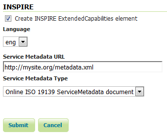
Once on the service configuration page, there will be a block titled INSPIRE. If you enable the checkbox shown above this section will have three additional settings:
Language combo box, for setting the Supported, Default, and Response languages
Service Metadata URL field, a URL containing the location of the metadata associated with the service
Service Metadata Type combo box, for detailing whether the metadata came from a CSW (Catalog Service) or a standalone metadata file
INSPIRE-related options
After clicking Submit on this page, any changes will be immediately reflected in the services (WMS 1.3.0 or WMTS 1.0.0) capabilities document.
Note
At the time of writing the INSPIRE Schemas only allow 23 choices for Language. The GeoServer INSPIRE extension allows some other languages to be chosen. If you choose one of these your capabilities document won’t be Schema valid but, as discussed in issue 7388, the INSPIRE Schemas seem to be at fault. If you have some other language you want adding to the list then please raise the issue.
Note
The Service Metadata URL field is mandatory so you will not be allowed to submit a blank value.
Note
The Service Metadata Type combo box only allows to select the appropriate MIME type for a CSW response or standalone metadata file or to omit a value altogether. If you think other values would be useful you could raise the issue on the GeoServer mailing list. In the meantime it is possible to manually edit the created configuration files as a workaround.
Note
Currently GeoServer does not offer the ability to configure alternate languages, as there is no way for an administrator to configure multiple responses. There is an open issue on the GeoServer issue tracker that we are hoping to secure funding for. If you are interested in implementing or funding this improvement, please raise the issue on the GeoServer mailing list.
Extended WMS and WMTS Capabilities
Note
The INSPIRE extension only modifies the WMS 1.3.0 response, so please make sure that you are viewing the correct capabilities document.
The WMS 1.3.0 and WMTS 1.0.0 capabilities document will contain two additional entries in the xsi:schemaLocation of the root <WMS_Capabilities> tag once the INSPIRE extension is installed:
http://inspire.ec.europa.eu/schemas/inspire_vs/1.0https://inspire.ec.europa.eu/schemas/inspire_vs/1.0/inspire_vs.xsd
If you have enabled the check box to create the INSPIRE ExtendedCapabilities element and entered the values described in the previous section then there will also be an additional ExtendedCapabilities block. This tag block shows up in between the tags for <Exception> and <Layer>. It contains the following information:
Metadata URL and MIME type
Supported Language(s)
Response Language
With the example values shown in the above configuration panel, this block would contain the following content:
<inspire_vs:ExtendedCapabilities>
 <inspire_common:MetadataUrl>
  <inspire_common:URL>http://mysite.org/metadata.xml</inspire_common:URL>
  <inspire_common:MediaType>
   application/vnd.iso.19139+xml
  </inspire_common:MediaType>
 </inspire_common:MetadataUrl>
 <inspire_common:SupportedLanguages>
  <inspire_common:DefaultLanguage>
   <inspire_common:Language>eng</inspire_common:Language>
  </inspire_common:DefaultLanguage>
 </inspire_common:SupportedLanguages>
 <inspire_common:ResponseLanguage>
  <inspire_common:Language>eng</inspire_common:Language>
 </inspire_common:ResponseLanguage>
</inspire_vs:ExtendedCapabilities>
ISNPIRE recommends that every layer offered by a INSPIRE WMTS should use the InspireCRS84Quad grid set which is already configured in GeoServer, but is up to the user to select it when publishing a INSPIRE WMTS layer.
Extended WFS and WCS configuration
INSPIRE-specific configuration is accessed on the main WFS settings and WCS settings pages in the Web administration interface. These are accessed by clicking on the WFS and WCS links on the sidebar respectively.
Note
You must be logged in as an administrator to edit WFS configuration.
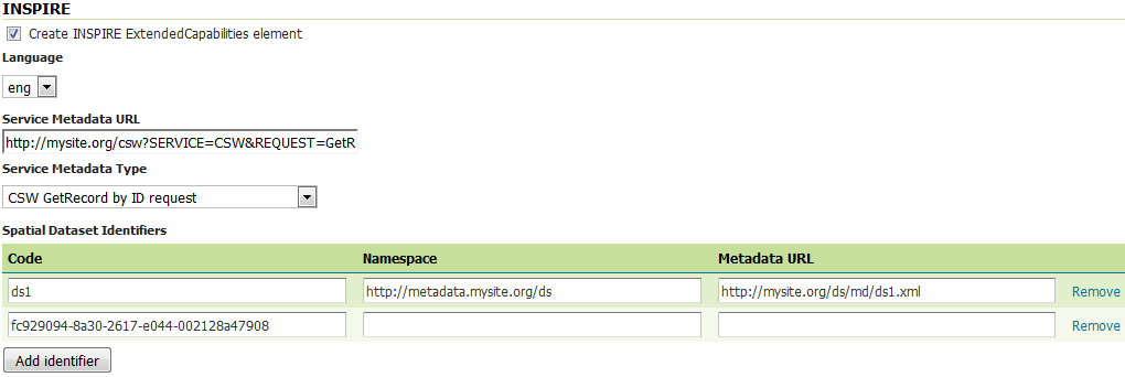
Once on the WFS or WCS configuration page, there will be a block titled INSPIRE. If you enable the checkbox shown above this section will have the following additional settings:
Language combo box, for setting the Supported, Default, and Response languages
Service Metadata URL field, a URL containing the location of the metadata associated with the WFS or WCS
Service Metadata Type combo box, for detailing whether the metadata came from a CSW (Catalog Service) or a standalone metadata file
Spatial dataset identifers table, where you can specify a code (mandatory), a namespace (optional) and a metadata URL (optional) for each spatial data set the WFS or WCS is offering
INSPIRE-related options
After clicking Submit on this page, any changes will be immediately reflected in the WFS 1.1 and WFS 2.0 or WCS 2.0 capabilities documents as appropriate.
Note
At the time of writing the INSPIRE Schemas only allow 23 choices for Language. The GeoServer INSPIRE extension allows some other languages to be chosen. If you choose one of these your capabilities document won’t be Schema valid but, as discussed in issue 7388, the INSPIRE Schemas seem to be at fault. If you have some other language you want adding to the list then please raise the issue.
Note
The Service Metadata URL field and at least one Spatial dataset identifers entry are mandatory so you will not be allowed to submit the page without these.
Note
The Service Metadata Type combo box only allows to select the appropriate MIME type for a CSW response or standalone metadata file or to omit a value altogether. If you think other values would be useful you could raise the issue on the GeoServer mailing list. In the meantime it is possible to manually edit the created configuration files as a workaround.
Note
Currently GeoServer does not offer the ability to configure alternate languages, as there is no way for an administrator to configure multiple responses. There is an open issue on the GeoServer issue tracker that we are hoping to secure funding for. If you are interested in implementing or funding this improvement, please raise the issue on the GeoServer mailing list.
Extended WFS and WCS Capabilities
Note
The INSPIRE directive is relevant to WFS 1.1 and 2.0 and WCS 2.0 only, so please make sure that you are viewing the correct capabilities document.
The WFS and WCS capabilities documents will contain two additional entries in the xsi:schemaLocation of the root element tag once the INSPIRE extension is installed:
https://inspire.ec.europa.eu/schemas/common/1.0/common.xsdhttps://inspire.ec.europa.eu/schemas/inspire_dls/1.0/inspire_dls.xsd
If you have enabled the check box to create the INSPIRE ExtendedCapabilities element and entered the values described in the previous section then there will also be an additional ExtendedCapabilities block with the following information:
Metadata URL and MIME type
Supported Language(s)
Response Language
Spatial data identifier(s)
With the example values shown in the above configuration panel, this block would contain the following content:
<inspire_dls:ExtendedCapabilities>
 <inspire_common:MetadataUrl>
  <inspire_common:URL>
   http://mysite.org/csw?SERVICE=CSW&REQUEST=GetRecordById&ID=wfs2&
  </inspire_common:URL>
  <inspire_common:MediaType>
   application/vnd.ogc.csw.GetRecordByIdResponse_xml
  </inspire_common:MediaType>
 </inspire_common:MetadataUrl>
 <inspire_common:SupportedLanguages>
  <inspire_common:DefaultLanguage>
   <inspire_common:Language>eng</inspire_common:Language>
  </inspire_common:DefaultLanguage>
 </inspire_common:SupportedLanguages>
 <inspire_common:ResponseLanguage>
  <inspire_common:Language>eng</inspire_common:Language>
 </inspire_common:ResponseLanguage>
 <inspire_dls:SpatialDataSetIdentifier
  metadataURL="http://mysite.org/ds/md/ds1.xml">
  <inspire_common:Code>ds1</inspire_common:Code>
  <inspire_common:Namespace>
   http://metadata.mysite.org/ds
  </inspire_common:Namespace>
 </inspire_dls:SpatialDataSetIdentifier>
 <inspire_dls:SpatialDataSetIdentifier>
  <inspire_common:Code>
   fc929094-8a30-2617-e044-002128a47908
  </inspire_common:Code>
 </inspire_dls:SpatialDataSetIdentifier>
</inspire_dls:ExtendedCapabilities>
The spatial data identifiers section is mandatory, but cannot be filled by default, it is your duty to provide at least one spatial dataset identifier (see the INSPIRE download service technical guidelines for more information).