External Web Map Server
GeoServer has the ability to proxy a remote Web Map Service (WMS). Supported WMS versions are 1.1.1 and 1.3.0. This process is sometimes known as Cascading WMS. Loading a remote WMS is useful for many reasons. If you don’t manage or have access to the remote WMS, you can now manage its output as if it were local. Even if the remote WMS is not GeoServer, you can use GeoServer features to treat its output (watermarking, decoration, printing, etc).
To access a remote WMS, it is necessary to load it as a store in GeoServer. GeoServer must be able to access the capabilities document of the remote WMS for the store to be successfully loaded.
Adding an external WMS
To connect to an external WMS, it is necessary to load it as a new store. To start, in the Web administration interface, navigate to . The option is listed under Other Data Sources.
Adding an external WMS as a store
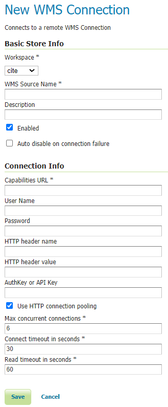
Configuring a new external WMS store
Option |
Description |
Workspace |
Name of the workspace to contain the store. This will also be the prefix of all of the layer names published from the store. The workspace name on the remote WMS is not cascaded. |
Data Source Name |
Name of the store as known to GeoServer. |
Description |
Description of the store. |
Enabled |
Enables the store. If disabled, no data from the remote WMS will be served. |
Capabilities URL |
The URL to access the capabilities document of the remote WMS. If URL contains just server address “https://host.org/wms” the required WMS GetCapabilities query parameters will be added automatically. Alternatively URL can be a full URL to access the capabilities document “https://host.org/wms?service=WMS&version=1.1.1&request=GetCapabilities”. |
User Name |
If the WMS requires authentication, the user name to connect as. |
Password |
If the WMS requires authentication, the password to connect with. |
HTTP header name |
If the WMS requires a custom HTTP header, the header name. |
HTTP header value |
If the WMS requires a custom HTTP header, the header value. |
AuthKey/API key |
If the WMS requires an Authentication key in the querystring, provide a key=value pair. |
Max concurrent connections |
The maximum number of persistent connections to keep for this WMS. |
When finished, click Save.
Configuring external WMS layers
When properly loaded, all layers served by the external WMS will be available to GeoServer. Before they can be served, however, they will need to be individually configured (published) as new layers. See the section on Layers for how to add and edit new layers. Once published, these layers will show up in the Layer Preview and as part of the WMS capabilities document.
Features
Connecting a remote WMS allows for the following features:
Dynamic reprojection. While the default projection for a layer is cascaded, it is possible to pass the SRS parameter through to the remote WMS. Should that SRS not be valid on the remote server, GeoServer will dynamically reproject the images sent to it from the remote WMS.
GetFeatureInfo. WMS GetFeatureInfo requests will be passed to the remote WMS. If the remote WMS supports the
application/vnd.ogc.gmlformat the request will be successful.Full REST Configuration. See the REST section for more information about the GeoServer REST interface.
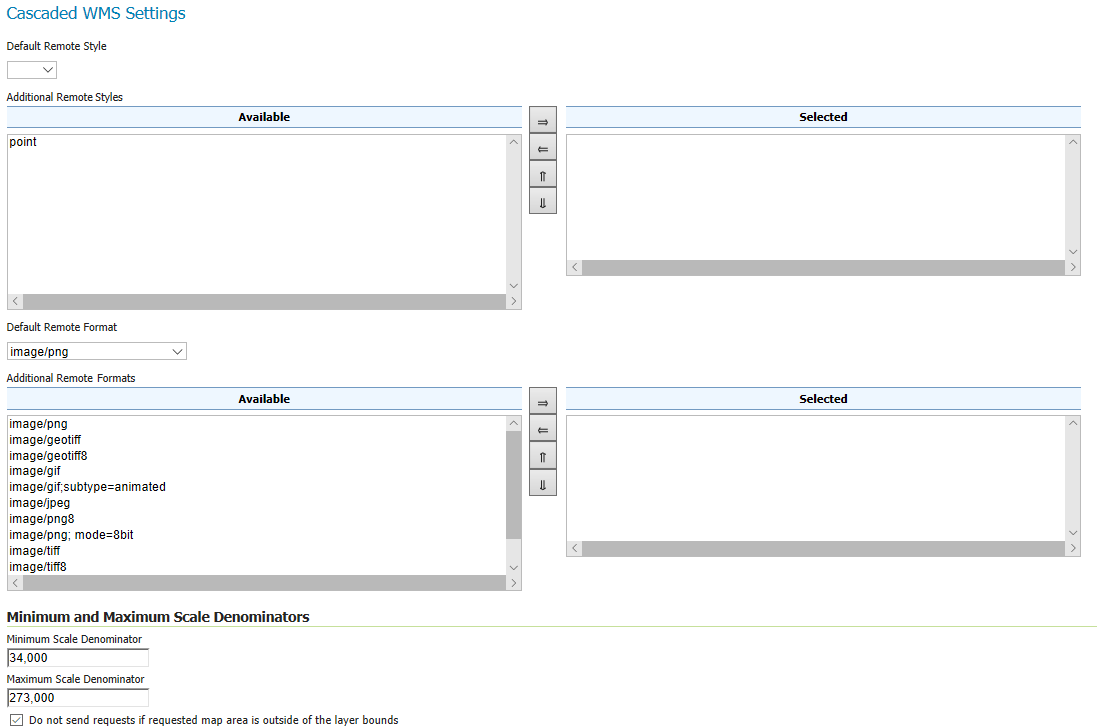
Cascaded WMS Settings
Making use of Remotely advertised styles and supported image formats.
Remote Styles Configuration. Remote Styles advertised in WMS capability document under <Layer> tag, can also be used. A default style and additionally supported styles can be selected. By default no remote style is selected which indicates Geoserver to use whatever style is configured remotely and all available styles are selected. This means that remote styles can be passed in a GetMap request just like local styles. If the styles on remote WMS server have changed, please re-save the layer from UI.
Remote Image Format. Preferred image format(s) can be selected. It is possible to select a preferred image format and additionally supported image formats. This configuration works looks at the requested image format in local GetMap, if the GetMap format is either the preferred remote format or one of the many selected remote formats, the passed image format will be relayed in the remote WMS request. If the image format requested in local GetMap is neither the preferred remote image format nor in the list of Selected formats, the remote WMS format will use the preferred remote image format. This setting only works for image formats and ignore other advertised formats such as JSON, KML and SVG etc
Scale Denominators. Min and Max scale denominators can be applied to WMS layers. The effects of this configurations on the WMS layer are similar to that of scale denominators used in SLD as filters. See Rules
Respect Advertised Bounds. It is possible to ignore remote WMS requests with bounding box completely outside the advertised bounds of remote WMS layer. Some external WMS providers might respond with error instead of empty transparent image for WMS requests outside their advertised bounds, in such cases enable the check box to bar Geoserver from making empty WMS requests to WMS provider.
Vendor Parameters. If the external WMS vendor supports vendor specific parameters enter them here. The format is key value pairs separated by an ‘=’ ie. key=value or key=value1,value2,,value4 . The key cannot contain an ‘=’ character. Values can be strings, numbers or booleans. The Vendor parameters will be included in the request made to the external WMS server.
Limitations
Layers served through an external WMS have some, but not all of the functionality of a local WMS.
Layers cannot be styled with SLD.
Alternate (local) styles cannot be used.
Image format cannot be specified. GeoServer will attempt to request PNG images, and if that fails will use the remote server’s default image format.